- Australia ▾
- Topographic
▾
- Australia 50k Geoscience maps
- Australia 100k Geoscience maps
- Australia 250k Geoscience maps
- Australia 1.1m Geoscience maps
- New Zealand 50k maps
- New Zealand 250k maps
- New South Wales 25k maps
- New South Wales 50k maps
- New South Wales 100k maps
- Queensland 10k maps
- Queensland 25k maps
- Queensland 50k maps
- Queensland 100k maps
- Compasses
- Software
- GPS Systems
- Orienteering
- International ▾
- Wall Maps
▾
- World
- Australia & New Zealand
- Countries, Continents & Regions
- Historical
- Vintage National Geographic
- Australian Capital Territory
- New South Wales
- Northern Territory
- Queensland
- South Australia
- Tasmania
- Victoria
- Western Australia
- Celestial
- Children's
- Mining & Resources
- Wine Maps
- Healthcare
- Postcode Maps
- Electoral Maps
- Nautical ▾
- Flags
▾
- Australian Flag Sets & Banners
- Flag Bunting
- Handwavers
- Australian National Flags
- Aboriginal Flags
- Torres Strait Islander Flags
- International Flags
- Flagpoles & Accessories
- Australian Capital Territory Flags
- New South Wales Flags
- Northern Territory Flags
- Queensland Flags
- South Australia Flags
- Tasmania Flags
- Victoria Flags
- Western Australia Flags
- Gifts ▾
- Globes ▾
Dear valued customer. Please note that our checkout is not supported by old browsers. Please use a recent browser to access all checkout capabilities


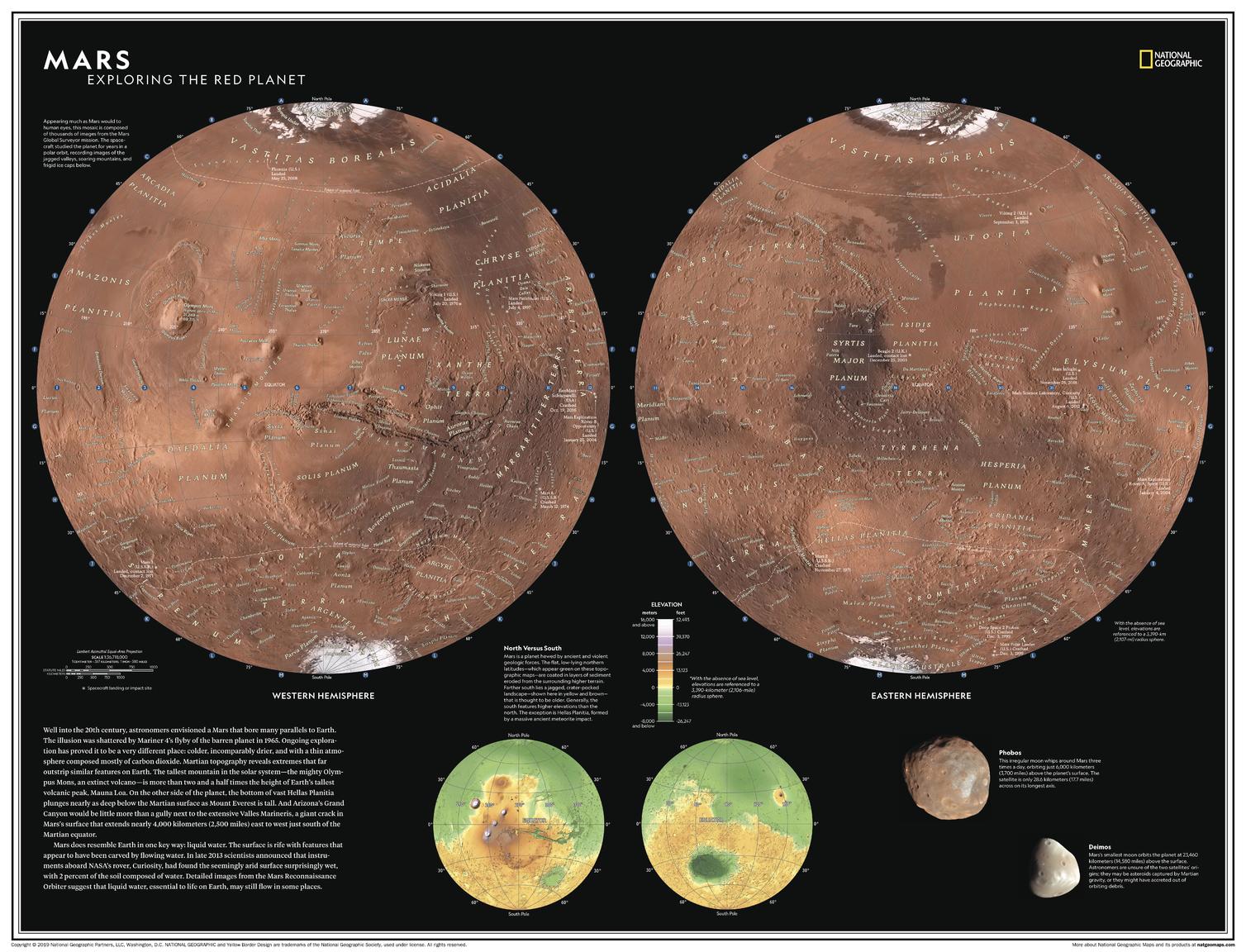
Mars: Exploring the Red Planet National Geographic 798 x 610mm Wall Map
$69.95
or make 4 interest-free payments of
$17.49 AUD
fortnightly with
![]() More info
More info
Well into the 20th century, astronomers envisioned a Mars that bore many parallels to Earth. The illusion was shattered by Mariner 4's flyby of the barren planet in 1965. Subsequent exploration has proved it to be a very different place: colder, incomparably drier, and with a thin atmosphere composed mostly of carbon dioxide. Martian topography reveals extremes that far outstrip similar features on Earth; the tallest mountain in the solar system - the mighty volcano Olympus Mons - is more than two and a half times the height of Earth's tallest volcanic peak, Mauna Loa.
Explore Earth's most researched neighbour with this compelling and attractive map of Mars! This dual hemisphere map, though depicting a world alien to our own, elicits a sense of familiarity with the way it is presented. Drawn in Lambert Azimuthal Equal-Area projection, this map offers a uniquely detailed look into the planet's physical features. A drawn fresco of Mars' rugged, inhabitable landscape provides context, as does a separate elevation map.
This map is an attractive product for the budding astronomer. It makes an essential companion to Milky Way: Earth's Galactic Home, and its size makes it perfect for a gallery wall.
This map is found in National Geographic's 11th Edition World Atlas and is now available as a stand-alone product.
The map can come either printed on heavyweight 160 gsm paper or laminated. The paper version is perfect for framing under glass, and the laminated version is exceptionally hard-wearing as we use a true encapsulation of two pieces of 80-micron gloss laminate.
Alternatively, we can supply this map on 395 gsm HP Professional Matte Canvas using pigment-based inks - making the map highly durable and fade-resistant. The exceptional clarity of printing makes this map a stunning addition to any room, and its high quality means that it will provide years of enjoyment.
The easiest way to hang your canvas map is by having wooden hang rollers attached top and bottom with a hanging cord on the top roller, so all you have to do is put a hook on the wall. The hang rails come lacquered in a natural timber colour.
Published: 2019
Size: 798 mm (w) x 610 mm (h)
Note: Please allow ten working days to deliver hang-railed maps as they need to be attached by our framer.
Made in Australia
Related Items


© 2024 Mapworld. Website designed by Genie Media
X